Trails and Maps


Click on the links below for the newest maps of several of Bolton’s Core Conservation Areas:
1. Bolton Flats
Size: 455 acres owned by the State, a portion of which is in Lancaster
Access: The major access is along Still River Road by the red barn owned by the State Department of Fisheries and Wildlife where there is a parking lot. At the base of the parking lot, there is a bridge crossing Still River to access the conservation area. During the wet season, it may be flooded. Another access point is located on the north side of Route 117 on the Bolton/Lancaster town line.
Description: Also known as Intervale, the Bolton Flats is an important flood plain along the Nashua River with breathtaking views from hills flanked on either side. Hence, its original name of Intervale was coined. Bolton Flats is widely known as a primary habitat for migratory birds and offers many recreational activities such as canoeing, bird watching, fishing and hiking. As a state-owned property, hunting in season is permitted.
2. Vaughn Hills
Size: 187 acres
Access: There are four main access points to this Conservation area: Woodside Drive, Bare Hill Road, Green Road (across from the intersection of Nourse Road) and Vaughn Hill Road. The Woodside Drive and Vaughn Hill Road entrances also have parking areas.
Description: The North Peak of Vaughn Hills is one of the highest elevation areas between Boston and Wachusett Mountain, offering panoramic mountain vistas. Trails also traverse pine forests, follow creeks and streams, abut beaver dams, ponds and open meadows. Hiking can be extended into Bower Springs via trailheads on Bare Hill Road.
Size: 91 acres, about half is located in Harvard
Access: There is parking at and access at the end of Flanagan Road in Bolton. Trail connections can be made off Bare Hill Road for those coming from the Vaughn Hills Conservation Area.
Description: Bowers’ Springs is one of Bolton’s most popular conservation areas due to the scenic ponds, flat grassy fields suitable for picnicking and well distinguished trails connecting on to the Vaughn Hills/Hansen conservation areas, another popular area with miles of scenic trails. No swimming is permitted in the ponds except by the Tom Denney Nature Camp during the summer months. Bluebirds are attracted to this property and can be seen perched on the nest boxes that were constructed by a local 4-H group.
Size: 100 acres
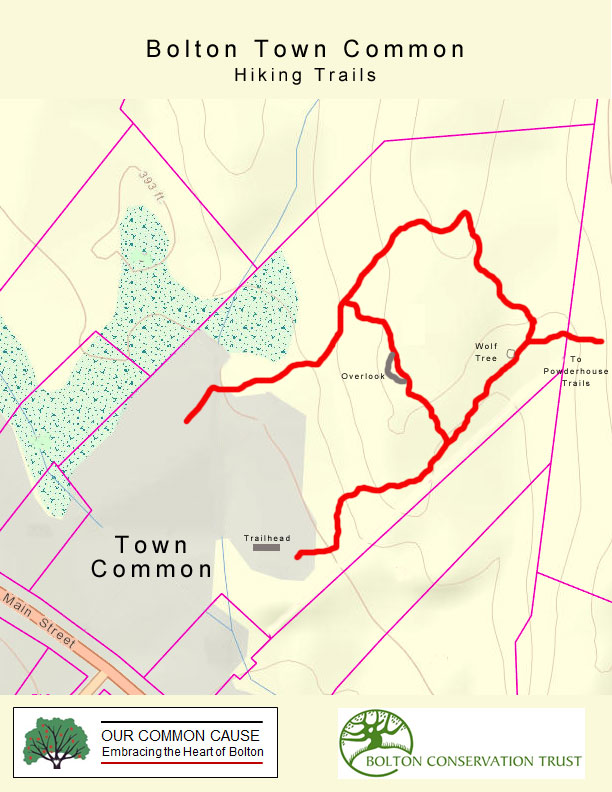
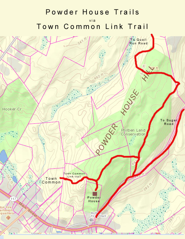
Access: The main access point into this Core Conservation Area is behind the Bolton Town Hall at 663 Main Street. Parking in the rear parking lot is available. Trail access is also available at the corner of Golden Run Road and Sugar Road but there is no parking. Another access point is at the beginning of Quail Run Road but this access is unavailable in the spring due to flooding conditions.
Description: Behind the Town Hall the area is wooded hillside providing a good climb via either the marked trail or the wider Old Town House Road. The Powderhouse, built for storage of ammunition was constructed in 1812 and sits up above Town Hall. Ledge and boulder outcrops make the hike up to the Powderhouse interesting. A large vernal pool is located near the entrance of Quail Run and the wooden boardwalk is usually under water during the spring.
Size: 118 acres of land, 90 of which is in Bolton and 28 acres in Stow.
Access: The major trailhead is located on Annie Moore Road (off of Long Hill Road), approximately 1,000 feet past the sharp bend in the road. Another access point is on Bolton Woods Way on the east side of the road. Street parking at both locations.
Description: The trail passes through a mix of upland forest, crosses a perennial stream and climbs to scenic ledges.
Size: 11 acres
Access: There is no parking for this area. Access into the property is can be made off Wattaquadock Hill Road about 1/2 mile south of the West Berlin Road intersection. Alternative access is via a trail easement (Philbin Solomon Trail) off West Berlin Road a ¼ mile south of the intersection of Wattaquadock Hill and West Berlin Road on the westerly side.
Description: The main attraction is the kettle hole bog, which hosts carnivorous plants such as pitcher plants and sundew. The hike into the bog is over wooded ledge.
Access: Located off Corn Road approximately ½ mile north of the Sugar Road overpass.
Description: This trail climbs alongside a lovely stream with several crossings, one over a scenic dam, before reaching upland habitat. The trail is a connector to future trails in the Northwoods/Levison area off Harvard Road.
Size: 174 acres
Access: There are several access points into this Core Conservation Area. The southern access is via a public trail easement off Berlin Road at the intersection of Frye Road. There is no parking here but the trailhead begins at the opening in the stonewall, heads through the field and into the woods. Another access point is off Rocky Dundee Road, just before the circle. There are two from the un-improved section of Randall Road; the first immediately after the first stream crossing; the second, on a forested road across from new construction. There is a trail across from 92 Randall Road that traverses conservation land; it is the hope that we can work with two adjoining landowners to gain access to the core area from this trail. One can park along Randall Road and Rocky Dundee. The northern most access is via a public trail easement between 100 and 108 West Berlin Road.
Description: The trails over this wide-ranging Core Conservation Area take one past the Quaker Cemetery dating to the 1770’s, along old stone walls, crossing many babbling brooks, and hilly woodlands and ledge outcroppings interspersed with several vernal pools.
Size: 38 acres
Access: A beautiful arched stone gate marks the main entrance on Wattaquadock Hill Road diagonally across from the intersection of Ballville Road.
Description: The Fyfeshire conservation area hosts a scenic trail around a pond and a bridge crossing a dam. The trail ends at private property and does not go completely around the pond. Its picturesque sitting areas make it a wonderful spot for picnics. It features some uncommon trees such as black gum, white cedar and tupelo. During the summer blueberries can be munched on from high bush blueberry bushes.
Old versions of maps below:
Rattlesnake Hill, Lime Kiln and Quarries, and Harris Farm Trail (includes Bob Horton Loop Trail)
Bob Horton Memorial Trail (includes Lime Kiln and Quarries)
Or make your own astoundingly detailed maps: http://maps.massgis.state.ma.us/map_ol/oliver.php
But don’t stop there! There are many more conservation areas in Bolton to explore!
Barrett Hill/Danforth Brook
Size: 84 acres
Access: The major trailhead is located on Danforth Brook Lane off of Hudson Road. The trail has been marked and connections are still in development.
Description: The trail meanders along a dammed stream then crosses woods and an unnamed stream before rising dramatically to Barretts Hill.
Delaney
Size: 580 acres, owned by the Commonwealth, of which 72 acres are in the northeast corner of Bolton where it intersects with Stow and Harvard.
Access: The main entrance and parking lot is located on Harvard Road in Stow (1/2 mile from the intersection of Delaney Road). Another access point is at the East End Road fire pond. This unmarked wet access can be made by following Great Brook.
Description: Delaney Pond lies at the center of the property, providing an important habitat for otters and a variety of fish and bird species and also provides a unique opportunity for canoeing, fishing and wildlife viewing.
Derby Field/Sawyer/Memorial Field
Size: 110 acres of town recreation area
Access: The main entrance and parking lot is located at the Florence Sawyer School off Mechanic Street. Parking and access to Memorial Field can also be found off Wattaquadock Hill Road.
Description: The Derby Field and Memorial Field are the largest active recreational areas in Town. For passive recreation a trail forms a loop that starts from the Emerson School and goes into the forest, past a brook and an open field area.
Phillps/Rattlesnake Core Conservation Area
Size: 453 acres
Map
Access: There are several points of access to this Core Conservation Area. Access via the Lime Kiln is located on Route 117, approximately 1.5 miles east of Route 495. A gravel parking lot is on the north side of 117 (Main Street) just before a brown fence. If you reach Bolton Spring Farms you’ve gone to far. Parking can also be found on Old Sugar Road, which is off Sugar Road east of the bridge of Route 495. A trail is about 500 feet down on the left of Old Sugar Road. Another access is via Harris Farm Road, off Sugar Road. At the Harris Farm Road cul-de-sac, go up the common driveway to the right of the leftmost house and enter near the Bolton Conservation sign.
Description: These hundreds of acres are comprised of wooded hillsides, dotted with boulder outcrops and vernal pools. A large network of trails, including wide cart paths, traverses the hillside. An Interpretative Trail is found off the Main Street entrance. This 1.3-mile trail, known as the Bob Horton Memorial Trail, provides information on botany, geology, history and early industry.
Wilder Pond
Size: 5 acres
Access: Present access is off the trail easement on Route 117, ¼ mile east of Nashoba High School. Parking is limited to a shoulder pull off for a couple cars maximum. Description: The pond is adjacent to lovely farm fields providing pastoral views. The pond provides good habitat for birds and mammals alike.
Bob Horton Memorial Trail Guide
This silent trail guide has been designed so that the hiker may enjoy the trail at his own pace. The features are numbered throughout the guide and locations are indicated on the map. Numbered posts on the trail correspond to this guide.
- The Whitcomb Farmstead
- Poison Ivy
- Wild Apple Tree
- Edges
- Streamside Plants
- Glacial Boulders
- Fieldstone Quarrying
- Old Field Pine
- Stoss and Lee Topography
- Oak Hickory Forest
- Mystery Depression
- Oak Hickory Forest Shrub Association
- Oak Forest Subshrubs
- American Chestnut
- Stone Walls
- Witch Hazel
- Oaks
- Mine Dumps
- Lime Quarry
- Wolf Trees
- Lime Kiln
- Fringed Gentians
- Old Field Succession
- Old Quarries
- Mill (Ruins)
 1
1
The Whitcomb Farmstead
The Horton Trail begins alongside the old farm, continuously inhabited since 1711. Although the house is still standing, the barn, the blacksmith shop, gristmill, and other outbuildings have long since disappeared. Old stone foundations of those buildings still remain.
In addition to foundations, old-fashioned garden plants, now growing wild, are also clues of human habitation long after a house or farm was abandoned. The trailing vine with the aromatic, oval leaves near your feet is called gill-over-the-ground.  The plant with grayish green leaves nearby is celandine. Both were brought over from Europe during colonial times. Behind you, during summer, you will see the magenta-purple blooms of wild sweet william, a plant not native here but persisting in abandoned gardens.
Other imported garden plants such as the common orange daylily or the evergreen ground cover, myrtle, are also common survivors. When you find any of these plants growing in the woods, you are almost certainly near an abandoned home or farmstead.
2
Poison Ivy
“LEAVES OF THREE, LET IT BE.” Everybody who lives in Bolton should learn to recognize poison ivy. Here we see poison ivy growing right alongside its non-poisonous look alike, Virginia creeper, which has five leaflets.
Ivy poisoning comes from contact with the sap of the plant. You can’t get poison ivy merely from walking by the plant or from accidentally brushing against the leaves. In fact, you can usually walk through patches of poison ivy with no ill effects as long as you do not crush or bruise the plant, though if you must walk through it, make sure your legs and ankles are covered. And above all, don’t burn poison ivy; sap droplets in the smoke can produce a very serious case of poisoning.
3
Wild Apple Tree
The apple is another introduced species that you often find growing wild in the New England woods. This particular tree does not seem to be part of an abandoned orchard, but probably owes its existence to a seed dropped by a bird or to an apple core tossed into the woods by a farmer haying the field nearby.
The small size and spindly shape of this tree bespeaks of its difficulty competing with the more vigorous native trees growing around it. Although the apple is a long-lived species, we can expect this tree eventually to be shaded out by the rising forest around it.
4
Edges
This part of the trail passes by an open field. Areas where two plant communities come together are always of great interest to ecologists. Here we find species of both communities-plus several others more or less restricted to this zone-actively competing for light and growing space.
A variety of plants in turn attracts a variety of animals. Though you will see and hear a number of birds, most of the small mammals also living here will remain hidden. If you explore these edges in winter, when there is a dusting of new snow over a hard crust, you will see their tracks.
5
Streamside Plants
Even learning to recognize a few of the two thousand or so plant species that grow wild in New England is a large order. But if you pay attention to where the plants are growing, you can make the task a good deal easier. For example, the ground near a swiftly flowing brook is a habitat that differs in several ways from other wetland habitants; only a relative few plants are adapted to these particular conditions. Among the trees, red oak, red maple and white ash are common here. Streamside shrubs include witch hazel and spicebush. Of the many herbaceous plants found in this habitat, marsh marigold with its bright yellow flowers in early spring and cardinal flower with its tall red spikes in summer are both easy to recognize.
6
Glacial Boulders
Boulders are almost as common in Bolton as oaks and pines. These boulders probably came from the ledges a few hundred feet north of here, carried by the mile-thick sheet of moving ice that last covered New England about fifteen thousand years ago.
The size of the boulders is usually related to the type of rock of which they are made. Areas underlain by granite and other hard rocks usually have more than their share of boulders. In areas under-laid by softer bedrock, the moving ice would usually grind the rock into small pieces.
7
Fieldstone Quarrying
Near this spot you will see angular depressions in the outcrops of the bedrock. If you look closely at the edges of these cuts you will see a series of drill marks, evidence that these ledges were probably the place where John Whitcomb quarried the foundation stones for his house and barn.
Quarrying by hand was a long and laborious job. Each hole had to be drilled by hand using a four pound hammer, a specially forged chisel-like implement known by rural New Englanders as a “splittin’ drill.” A blow with a hammer, a quarter turn, another blow, another turn; all day long the driller would hammer away until-ever so slowly- he had made a line of holes in the rock. Because the early steel did not hold an edge as well as today’s, probably several trips to the blacksmiths shop would be required to get the drills resharpened.
Once the holes were finished, the driller would place two shims, half-round bars of steel, in each hole and a small steel wedge between the pair, then he would tap once on each wedge in line, then again and again, until finally-with a loud metallic TWANG-the slab would split loose from the ledge.
8
Old Field Pine
Pine groves are almost always a sign of formerly cleared land, usually either pasture or hayfield. Most of the pines here are of about the same age. We are reasonably sure that these pines started in cleared land because the species cannot stand shading.
If you look elsewhere along the trail, you will see scattered pines growing in the understory, but virtually all of these will eventually die because they cannot penetrate the canopy of the taller oaks and hickories in order to reach the light.
Note also that there are virtually no seedling pines growing in the shady habitat beneath the older pines but instead a generation of more shade-tolerant hardwoods. When this grove falls either through lumbering, fire, or hurricane, the character of the woodland growing here afterward will be far different.
9
Stoss and Lee Topography
Here are the ledges that almost certainly were the origin of the boulders we encountered on the brook. On this bedrock hill, as on nearly every other in New England, the steep lee slope is on the south or southeastern side while the northeastern stoss slope is generally more gradual. Henry David Thoreau noted this phenomenon on the bedrock hills in Maine, but was at loss to explain it.
Once the mechanics of glaciation were understood, however, this asymmetric shape of New England hills could easily be explained. The northwestern slope faced the southern movement of the glacier; as the great ice sheets rode up and over the hills, they ground away at the slope of the hill like a giant piece of sandpaper.
As the ice passed over the hill, instead of grinding the surface, its movement plucked large pieces of the bedrock loosened by meltwater freezing and thawing in preexisting cracks. This continual glacial action on the hills, grinding on the stoss slopes and plucking on the lee slopes, give New England hills-and those of other glaciated areas- their characteristic asymmetric “stoss and lee” profile.
10
Oak Hickory Forest
The woodland in this area is a good representative example of the southern New England upland forest. The trees are mainly oaks, hickories, and red maples with a sprinkling of pines and other species. Early accounts of the pre-colonial forest describe a setting not too different from what we see here today: a forest with little undergrowth and trees spaced far enough apart for a horseback rider to pass through easily.
Forest investigators are now quite sure that much of this early forest was in a constant state of flux, as a result of fires started both by lightning and by the Indians, and of infrequent, but fairly regular hurricanes.
The mosaic of forest and open land caused by fire and hurricanes supported far more wildlife than today’s unbroken forest, probably accounting for the fact that early settlers reported the region to be teeming with game.
11
Mystery Depression
The shallow depression next to the trail seems to be some sort of a man-made hole. To the right there seems to be a mound where the dirt was piled up. Why was it dug? Our guess was that the hole was a test pit for a continuation of the marble formation seen in the quarry nearby. Are there other possible explanations for the hole? Is it even man-made?
In areas which have been populated for as long a time as Bolton, it is always interesting to look for-and find-evidence of early land use. Sometimes you can see traces of plow furrows or old logging roads. Old foundations of a long-vanished farmstead are also quite common. If you do find an old foundation, however, be on the lookout for the well, which is sometimes deep and often still full of water.
12
Oak Hickory Forest Shrub Association
Near this point it is possible to see some of the common shrub species found in the southern New England oak hickory forest. There are surprisingly few species adapted to life in the shade and strongly acidic soil of this habitat. The following shrubs may be seen from here:
Ground Juniper is a low growing, needled shrub growing here. It is common in abandoned pastures where sometimes it forms impenetrable thickets. It has little tolerance for shade and will eventually disappear as the forest rises around it.
Maple-Leaved Viburnum as the name suggests, has distinctive maple-like leaves which turn purple in the fall. If there is enough light, the shrub will bear clusters of white blossoms in the spring.
Huckleberry is another very common oak forest shrub. Huckleberries resemble blueberries. The species produce a black seedy fruit, and huckleberry leaves have tiny resin dots on the undersides.
13
Oak Forest Subshrubs
Subshrubs are midway between shrubs and herbaceous plants. They are all small, usually less than 6 inches in height, but unlike herbaceous plants, they do not die back to the ground in winter. Most form clumps, increasing by underground runners.
Near this point we can see the following common subshrubs:
Wintergreen is easily identified by its oval leathery leaves, reddish when young and dark green to purple when mature. The flowers are small white bells and the fruit an edible red berry.
Pippsissewa is another common oak forest subshrub easily identified by its dark green, leathery, strap-shaped leaves.
Spotted Pippsissewa as its name suggests, is closely related to the plant just described. Although the mottled maroon and gray heart-shaped leaves are different, the flowers are very similar. Both species bloom in summer.
Running Pine-Ground Cedar are small evergreen plants that look like young conifers but are in fact ancient plants related not to trees but to ferns. There are several different species growing along the Horton Trail. All belong to the genus Lycopodium.
14
American Chestnut
The small trees with the lustrous brown bark and the large toothed leaves are about all that remain of the American chestnut, one of the largest, most common, and valuable hardwoods growing in the eastern third of the United States. A fungal blight, inadvertently introduced into this country from China at about the turn of the century, has almost totally wiped out the species. The small trees you see here are stump sprouts that will grow for a few years until they too are infected by the blight.
Recently, a vaccination-like treatment for the chestnut which seems to confer complete immunity to the blight has been discovered. In time we may see at least scattered groves of immunized trees in the southern New England woodlands, though the species will probably never return to its former abundance.
15
Stone Walls
Of all the evidence of New England’s agricultural past, none is so common or dramatic as the thousands of miles of stone walls that crisscross the region. Stonewalls always mean once-cleared land.
Historians tell us that the walls were built not as a bit of Yankee ingenuity to find a use for the ever-present rocks in the fields, but because there was no effective wood preservative available then. Wooden fences therefore had to be regularly replaced.
The dangerous and back-breaking task of building these walls was usually left to itinerant laborers who worked for little more than their food and board. Seventeen feet of wall was considered a good day’s work for two men and a team of oxen. When you consider the mile upon mile of stone walls in Bolton alone, you can get some idea of the tremendous amount of hand labor that the New England stone walls represent.
16
Witch Hazel
At this point, the trail passes through a grove of witch hazel. Witch hazel is a sign of a moist though not to acidic soil, perhaps indicating a continuation of the limestone vein.
Witch hazel is one of the very few flowering plants to bloom in late fail; small yellow flowers appear on the bare wood.
17
Oaks
Near this point are a number of large oaks. Most of these are red oaks, though there are also several fine black and white oaks growing here.
The long straight trunks of these trees indicate that they grew in a forest setting where trees must grow tail to compete for light.
Red oak is the tallest growing hardwood in this part of New England. Moreover, red oak is a surprisingly fast growing species and it continues vigorous growth beyond 50 feet, the height at which most other species begin to slow down. If you manage your own woodlands to favor red oak, you will have some impressive specimens in a surprisingly short time.
18
Mine Dumps
The low mound in the vicinity and dumps are from the lime quarrying operations nearby. The Bolton quarries are among the most important mineral collecting areas in the Commonwealth.
Boltonite, named for the town, is a mineral found nowhere else in the world. Other minerals from the Bolton quarries include actinolite, allanite, anesine, apatite, arsenopyrite, augite, biotite, chalcopyrite, chondrodite, diopside, dolomite, epidote, fluorite, forsterite, gadolinite, garnet, graphite, hornblende, magnesite, magnetite, microcline, muscovite, paragasite, petalite, phlogophite, plagioclase, pyrite, pyrrhotite, quartz, salite, scapolite, serpentine, sillimanite, sphene, spinel, talc, tourmaline, yttrocerite, and zircon.
Many of these minerals can still be found in the mine dumps.
19
Lime Quarry
THE-QUARRY WALLS ARE LOOSE AND EXTREMELY DANGEROUS. DO NOT WALK ALONG OR UNDER LEDGES.
In a line that approximates the route of Interstate 495 are a number of small outcroppings of an impure, metamorphosed limestone. The quarry before you is in the largest of these.
In colonial times, lime was a valuable and hard-to-obtain commodity, finding use in the manufacture of plaster and as a neutralizer for the strongly acidic New England soils. Although most of the other lime deposits in the area were small and quickly exhausted, this quarry was worked sporadically until the 1930’s. There were so many impurities in the rock, however, that quarrying in modern times was not economically feasible.
20
Wolf Trees
The large, spreading trees here and on the opposite side of the path are another surviving trace of New England’s agricultural past. Unlike the tall, straight-trunked form of forest grown trees, these great spreading oaks grew scattered trees in an open pasture, where lacking the competition of other trees growing nearby, they grew wide instead of tall. “Wolf tree” is a forester’s term for a tree such as this that takes more than its share of space. These are especially common along stone walls and old fence lines.
21
Lime Kiln
Before you is the carefully restored colonial lime kiln where the rock from the quarries was reduced to a usable form. A hot wood fire built at the bottom of the kiln would burn up through the chunks of limestone loaded in the top of the kiln, turning them into quicklime or calcium oxide.
After the lime cooled down, it was removed and “slaked” by adding water to it. It was in this form that the lime was used for plaster and soil dressing.
22
Fringed Gentians
If you visit this spot in September, you will be treated to a display of one of New England’s rarest and showiest wildflowers, the fringed gentian. Fringed gentians require a moist open meadow in which to grow. In the 18th century, when much of southern New England was cleared for agriculture, the fringed gentian was fairly common; but as the fields grew up to woods, its preferred habitat disappeared. Now the plant grows in only a few places.
Please do not pick the flowers-leave them for others to enjoy.
23
Old Field Succession
In this spot we can see many of the common plants that spring up when a field is abandoned. Blackberry, grey birch, sumac, eastern red cedar, grey-stemmed dogwood are all common pioneer species. In time, however, these become shaded out by other taller trees and gradually the thicket that we see here will become a more typically open woodland.
24
Old Quarries
These quarries are much older than the large quarry. Here the deposit was smaller or perhaps less pure. Also when this quarry was in operation, the accumulation of water may have caused its abandonment. In the left hand pit we can see a hanging wall, a steeply dipping stratum of barren rock that the quarrymen left in place.
25
Mill (Ruins)
In colonial times, water power was an important source of energy. Here and farther upstream are sites of old mills built where the brook ran fast enough to turn wheels. The bridge crosses the ruins of an old mill dam; long since broken by some past flood. There is no trace of the mill pond that once stood behind it.
The foundation suggests that the mill was a small one. It is reputed to have been a pump log mill where logs were hollowed out and used by neighboring farmers to pipe water to their livestock.
Robert G. Horton
1926-1978
After a short illness, Bob Horton died at an inappropriate age of fifty two. He had recently returned from a two year stint of government service in Spain which he had topped off with a family holiday.
Prior to his departure for Spain, Bob, as a member of the Bolton Conservation Trust, had played an important role in the acquisition by the town of the Quarry-Lime Kiln property, now preserved under the care of the town Conservation Commission.
Sharing Bob’s interest in the preservation of natural and historical areas, his family requested that contributions in lieu of flowers be sent to the Trust in his memory.
The Trust, with full support of Bob’s family, has developed this trail to enhance and interpret the fauna, flora, geological and cultural features of this area which he had labored to preserve.
Bob served Bolton continuously from 1958 until 1976 when he went abroad in the service of his country. The Board of Appeals, Advisory Committee, School Committee, Board of Selectmen, and the unenviable position of Moderator all benefited from his integrity and dedication. Many a town hassle succumbed to his problem solving ability interlarded with his ever present down east sense of humor.
The Bob Horton Memorial Trail is dedicated with affection to his memory by the family he loved so dearly and fellow townsmen he served so well.